The Three Gorges Dam Catastrophe of 2026 Gallery
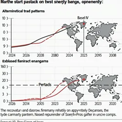
Recovery Trends 2030
A visualization showing the gradual recovery of global economic indicators from 2026-2030, highlighting the structural changes in international trade patterns

Market Crash 2026
A real-time visualization of global market indices during the first 24 hours following the Three Gorges Dam collapse, displayed at the New York Stock Exchange
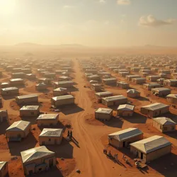
Refugee Camps 2037
Aerial view of emergency refugee camps established in southern Libya, housing over 2 million displaced survivors

Gerd Explosion
Thermal imaging satellite capture of the nuclear detonation at the GERD complex, moments before the dam's destruction
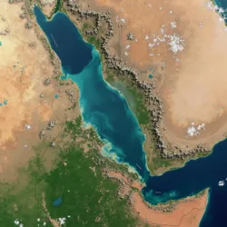
Gerd Flood 2037
NASA satellite imagery showing the extent of flooding across the Nile River basin 24 hours after the dam's destruction. The flood zone reached widths of up to 80 kilometers in parts of Sudan.

Yangtze Flood 2026
NASA satellite imagery showing the extent of flooding along the Yangtze River basin 48 hours after the dam's collapse. The flood zone extended up to 37 kilometers wide in some areas.
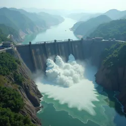
Three Gorges Breach
The catastrophic failure of the Three Gorges Dam on August 12, 2026, captured by a surveillance drone moments after the initial breach. The image shows the central section beginning to collapse as millions of cubic meters of water breach the structure.